Here are the hikes we are going to cover, the ones we've personally done up
to this point. Again, we've just started this project, so you may only see a list
of the trails we've hiked at this point. The list will gradually be filled in with narrative and pictures.
I don't know yet whether we'll put them all on the same page or provide
separate links to each hike. Probably the latter.Click on any of the hike names to be taken directly
to that hike.

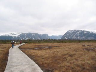 Western Brook Pond
- This is the first
trail we hike in the spring, and the last one we hike in the fall. It leads
to Western Brook Pond and its magnificent fjord. It's a relatively easy
hike, taking about a half hour to forty-five minutes each way. There's a
boat trip up the fjord that you may choose to take. You'd have to make
reservations for the boat trip before you go in there. The boat trip is
worth it. Gros Morne is a geological wonder. The boat trip highlights
why it is a wonder. About three quarters of the way in to the
pond, you'll be
offered the choice of taking a slightly longer option that will lead you
along a portion of Western Brook itself. You may do this either coming or
going. If you have the time, do it on the trip IN to Western Brook; it's
more interesting that way because you have the view in front of you all the
time. The trail is fairly wide with lots of boardwalk and only a short,
gentle incline or two. Sneakers would be fine. Anyone who can walk downtown for an hour and a half
could easily take this hike. For the more adventurous, the boat can
drop you at the head of the gorge and you can do a three or four DAY
traverse of the mountains. (We haven't done this, so we can't comment
on it one way or another. Just don't choose lightly to do this. You'd
need good mapping skills, and you'd have to be in superior condition.
Conditions on the mountain can change very rapidly.) As I've said, we do this
trail in the early spring and in the late fall. At other times the trail can
be quite crowded because of people taking the boat tour. We prefer to have
the park to ourselves. We're spoiled.
Return to list of trails!

Discovery Centre Trail - You'll have
to be in decent shape for this one. The trail leaves from immediately behind
the Discovery Centre (well worth visiting) on the South Side of Gros Morne.
To get to the South Side of the Park (Gros Morne of course), you make a left
turn immediately after you pass the kiosk at the entrance to the park.
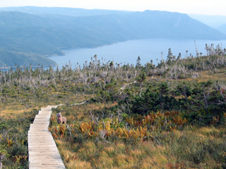 Just
before you get to Woody Point you have to take a VERY sharp left, uphill
turn. The first kilometer or so of this road is VERY rough, but it does get
better, and they're working on it. The trail is uphill. After rain you may
hit some muddy, slippery spots, but generally it's quite good. It will take
you about 45 minutes to an hour to get to the base of the lookout. You'll
see the last string of steps in front of you. You have to make a choice
here: Do you go left, or do you go up the steps? We'd recommend you go
left at this point. This will take you through a mountain meadow with
the tablelands stretched out in front of you. As it winds around to the
lookout, you'll see Bonne Bay and Gros Morne (the mountain). When you
get to the lookout, then you can choose to walk down the steps, or go
back the way you came. The walk through the meadow (all boardwalk), will
take 15 to 20 minutes. The return to the parking lot will take about 45
minutes. If you don't have it in you do the James Callahan Trail (the trail
to the top of Gros Morne itself), then this is the next best thing in terms
of the view and scenery. It may even be better. Wear light hiking boots
for this if you have them. You need something with good traction and
support, even though we've done it several times in sneakers. On the way up,
when you get to the first lengthy boardwalk, the toughest part of the trail
is over. It's all pure pleasure from there. On the steep part,
if you get discouraged, just turn around and look at the view. That will
energize you. (Remember, through all my comments, that I'm overweight
and pushing 60. My legs are still in good shape, but I could stand to lose
40 pounds and get a few more hours exercise a day.)
Return to list of trails!

Green Gardens -
This is the latest hike we've done (Oct. 5, 2003). We returned
to it after about a sixteen year absence. It's still a tough hike.
VERY tough if you do the full loop. We didn't. (I did it once.) You
may start this hike from either end of the loop. Parking lots are on the
highway to Trout River. We've always started the hike from the lot closer to
Trout River. If you just want to go in to the coast and come back out,
that's what I'd suggest. I think the coast near that end of the trail is
more spectacular. You start the hike with about a 20 minute hike up the side
of the hill that's facing you. Then it's downhill (with a few "bumps")
all the way to the coast.
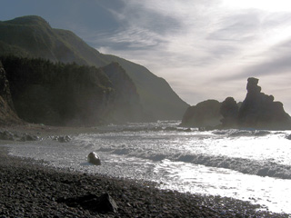 This stage will take about 50 minutes to and
hour - about an hour and fifteen minutes total. Once you're at the coast, if
you go a very short distance you'll find a length of steps leading down to
the "beach". Go down there. Have your picnic. Then, if you're
going straight back out, take your time. Maybe go a little ways along the
meadows. This is where folk from Trout River and other communities keep
their sheep. Watch your step. The trip back out is pretty tough (at least it was for an old
fellow like me). Piqa loved it.
Especially chasing the sheep (or trying to - we got her on lead before she
actually knew what they were and that they'd run from her). The trail
is a little rougher than many of the others. In places along the
trail, because travel has exposed the soil, the soil has been washed away
and medium sized rocks are plentiful. You have to be alert or you could
easily turn an ankle or trip. This is NOT an easy hike. It took us about
three and a half hours to go in and out. We spent about 45 minutes to
an hour having our picnic and taking pictures. If you do the loop (and
it gets harder going out the other way), you'll need about six hours. Wear
good footwear.
(Semper ubi sub ubi!)
Return to list of trails!

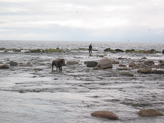
Green Point Green Point
Trail is actually a stroll along the coast. It's quite pleasant, can be
windy at times. You have the ocean on one side and the fjords of the Long
Range Mountains in the distance on the other side. There are a few
small ponds that are occasionally visited by ducks and geese. At the mouth
of Baker's Brook at one end of the trail you will frequently see fishermen
after sea trout. It is actually possible to hike just one way on this, as
both ends of the trail are at the highway. (Well, one end, the Green Point
end, is in the camp ground just off the highway.) But to do this, you'd need
someone to drive and pick you up unless, for some insane reason, you'd
choose to walk up the highway. This is a nice spot for a picnic.
Usually we drive to the campground, park the van in the trail parking
spaces, do our hike, then, when we come back, park the van in one of the
empty campsites and have our picnic. We'll take some snacks on the hike with
us. This is as trail we do several times a year. Carol likes it.
Return to list of trails!

Stuckless Wigwam - This trail turned out to be a very
pleasant surprise. We (I) thought it was a pond in the valley that we could
walk around in about an hour. It turned out to be a mountain pond. It took
us about 40 minutes to hike to the pond. We calculated (after we studied the
map), that it would take an additional two hours to go around the pond, so
we went for about another 20 minutes and then turned around. Piqa had a nice
swim in the beautiful mountain pond; she got the zoomies. It was so
pleasant we decided we'd come back and do the full hike. We'll allow four
hours for it and take a nice lunch. We may even do some trouting in the
spring.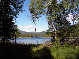 For now, we're going to wait until the leaves start to turn. It
should be wonderful in about two weeks (the end of September). So we'll wait
for a clear, cool day. There is a long incline on the way up to the pond,
and the trail isn't as well traveled as some, but, as far as we went, there
wasn't anything too challenging. I expect there are plenty of moose in the
area and a bear or two. (Talking about bears, we've only ever seen three,
all from the car. There is bear sign on most of the trails in the park. It's
only when we stop to think about it that we worry at all. But, we make
enough noise, and we have the dog who'll probably give us plenty of warning
and then run and hide behind us.) The hike could become a regular one,
especially if we have any luck trouting there in the spring. Our next
door neighbour tells us there are trout there. All "pan sized."
Return
to list of trails!

Trout River Pond -

Baker's Brook

Alexander Murray Trail
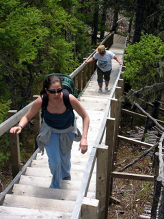
Step, steps, and more steps. This is beautifully prepared trail, a little
rough at the back end (going clockwise), but a great hike. You could
build a town with the amount of lumber used on this trail. The top of the
trail will see you overlooking Green Bay. There's a great little spot
there to eat your sandwiches and your oranges. Bring lots of water. Sneakers
should to it for hiking. The dogs had no problem. When we did this hike,
daughter and Myla the Boxer were with us. It was a lovely day.
The whole Green Bay area is lovely to explore. Later this year we hope
to take the ferry to Little Bay Islands and do some of the trails there.
Return
to list of trails!

Point Riche Lighthouse Trail
- This is not so much a trail as a stroll along the coast.
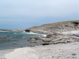 The trail
is "marked" only where needed by small boulders laid out in a line.
You don't really need them, but they'd come in handy if the fog rolled in
quickly. The rock formations are interesting. The trail leads to an
archeological dig. Archeologists claim that every archaic group that
ever lived in Newfoundland lived on this site at one time or other. Sneakers
will do for this. Any amount of time would suffice, even fifteen or
twenty minutes (up to perhaps two
 hours). You may turn around at any time.
Return to list of trails!
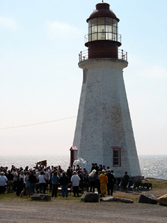
(The picture at left is of a wedding that
was taking place at the Point Riche Lighthouse when we pulled into the
parking lot to start our hike. I didn't want to intrude, so I took my
pictures from a distance. I'm sure though, that if we'd gotten a little
closer, we'd probably have been invited to the wedding. Such is the
nature of Newfoundland and Newfoundlanders.)

Burnt Cape
Salvage
Tilting
The Gravels
Blomidon Trail
SouthEast Brook Falls
Gros Morne
Anchor Point Wintering
Stanleyville
Sandy Pond - Terra Nova National Park


 Just
before you get to Woody Point you have to take a VERY sharp left, uphill
turn. The first kilometer or so of this road is VERY rough, but it does get
better, and they're working on it. The trail is uphill. After rain you may
hit some muddy, slippery spots, but generally it's quite good. It will take
you about 45 minutes to an hour to get to the base of the lookout. You'll
see the last string of steps in front of you. You have to make a choice
here: Do you go left, or do you go up the steps? We'd recommend you go
left at this point. This will take you through a mountain meadow with
the tablelands stretched out in front of you. As it winds around to the
lookout, you'll see Bonne Bay and Gros Morne (the mountain). When you
get to the lookout, then you can choose to walk down the steps, or go
back the way you came. The walk through the meadow (all boardwalk), will
take 15 to 20 minutes. The return to the parking lot will take about 45
minutes. If you don't have it in you do the James Callahan Trail (the trail
to the top of Gros Morne itself), then this is the next best thing in terms
of the view and scenery. It may even be better. Wear light hiking boots
for this if you have them. You need something with good traction and
support, even though we've done it several times in sneakers. On the way up,
when you get to the first lengthy boardwalk, the toughest part of the trail
is over. It's all pure pleasure from there. On the steep part,
if you get discouraged, just turn around and look at the view. That will
energize you. (Remember, through all my comments, that I'm overweight
and pushing 60. My legs are still in good shape, but I could stand to lose
40 pounds and get a few more hours exercise a day.)
  This stage will take about 50 minutes to and
hour - about an hour and fifteen minutes total. Once you're at the coast, if
you go a very short distance you'll find a length of steps leading down to
the "beach". Go down there. Have your picnic. Then, if you're
going straight back out, take your time. Maybe go a little ways along the
meadows. This is where folk from Trout River and other communities keep
their sheep. Watch your step. The trip back out is pretty tough (at least it was for an old
fellow like me). Piqa loved it.
Especially chasing the sheep (or trying to - we got her on lead before she
actually knew what they were and that they'd run from her). The trail
is a little rougher than many of the others. In places along the
trail, because travel has exposed the soil, the soil has been washed away
and medium sized rocks are plentiful. You have to be alert or you could
easily turn an ankle or trip. This is NOT an easy hike. It took us about
three and a half hours to go in and out. We spent about 45 minutes to
an hour having our picnic and taking pictures. If you do the loop (and
it gets harder going out the other way), you'll need about six hours. Wear
good footwear.
 For now, we're going to wait until the leaves start to turn. It
should be wonderful in about two weeks (the end of September). So we'll wait
for a clear, cool day. There is a long incline on the way up to the pond,
and the trail isn't as well traveled as some, but, as far as we went, there
wasn't anything too challenging. I expect there are plenty of moose in the
area and a bear or two. (Talking about bears, we've only ever seen three,
all from the car. There is bear sign on most of the trails in the park. It's
only when we stop to think about it that we worry at all. But, we make
enough noise, and we have the dog who'll probably give us plenty of warning
and then run and hide behind us.) The hike could become a regular one,
especially if we have any luck trouting there in the spring. Our next
door neighbour tells us there are trout there. All "pan sized."
 The trail
is "marked" only where needed by small boulders laid out in a line.
You don't really need them, but they'd come in handy if the fog rolled in
quickly. The rock formations are interesting. The trail leads to an
archeological dig. Archeologists claim that every archaic group that
ever lived in Newfoundland lived on this site at one time or other. Sneakers
will do for this. Any amount of time would suffice, even fifteen or
twenty minutes (up to perhaps two
 hours). You may turn around at any time.